 More
More Contact
 Submit
 Premium
 Kasba Tadla
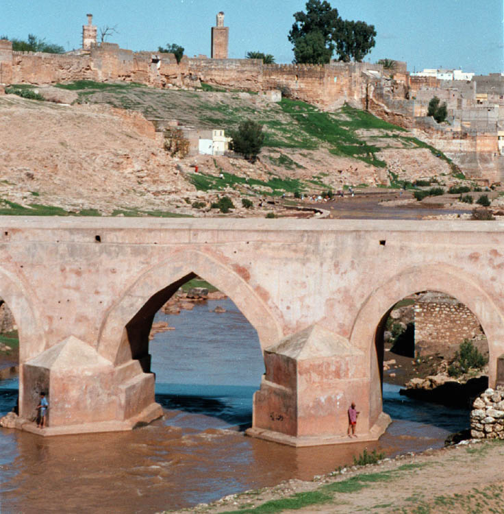
imposing citadel, Kasba Tadla dominates the region. Its architecture detaches noble the beauty of the ocher walls installed over the meandering river Oum er Rbia.
Kasba Tadla in history
time of struggles. Tadla Province, which occupies a sloping surface to the upper valley of the Oum er Rbia, probably corresponds to the region Fazazi mentioned by the Arab chroniclers. Any time of the plateau and mountain people of the Middle Atlas it is delivered fairly severe struggles. At the time Almoravid (eleventh and twelfth century), Tadla is impacted by the invasion of nomadic Hilalians.
Time dynasties. Almoravids and Almohads Merinid Wattasids populated plateau Arab groups increasingly numerous. In the sixteenth century, after ensuring the possession of Marrakesh, Saadiens interested in the wealth of this province. Under the Alawites, at the end of the seventeenth century, the troops Shereefian and the Middle Atlas Berbers face it.
The Citadel and the Black Guard. Moulay Ismail (1672-1727) managed to keep it uplifting in 1687, on the right bank of the Oum er Rbia, a mighty fortress that is protected by a contingent of 1000 soldiers of the Sudan, his famous "Black Guard "In 1700, he entrusted the government of the province to one of his two son, Ahmed Dehbi ed.
uploaded by his father to enlarge the initial casbahs, it prefers to raise another larger, nearby. He thinks and control the major outlet of valleys of the Middle Atlas Berber revolts or are still to be feared.
The impossible peace of Tadla. In 1818, the Berber tribes grouped under the authority of Abu Bakr Amhaouch, undo Moulay Slimane. In the late nineteenth century, Moulay el Hassan is not happy. To get from Fes to Marrakech, Mehalla Shereefian must then avoid the Tadla, and pass through Rabat and Dar el Beida (Casablanca).
Visit Kasbah Tadla
- First described times by Charles de Foucauld, the citadel is composed of two chambers separated by the lists.
It houses the imperial palace of the governor - the former Dar el Makhzen - two mosques and silos.
Along the crenellated walls of the kasbah, you can win a public garden near which stand the markets dominated by a mosque minaret carved tracery.
- Down from the cabinet, an old stone bridge with 10 arches built by Moulay Ismail crossed the Wadi Oum er Rbia. From there, splendid view of the kasbah, or stands a fortified built up river.
yet to see in the Beni region Mellal (32 Km South)
Boujad (26 km north-west);
Imilchil (136 km South-East).
From Kasba Tadla
Atlas and platform Lakes (245 km to Tineghir; only 61 km of paved road between Kasbah Tadla and Imilchil; takes 3 days to complete the route out of the period moussem Imilchil. Do not expect any supply of accommodation, providing everything necessary to bivouac and water supplies and gasoline. aways a detailed map of the region only possible route from May Ci October, all-terrain vehicle necessary). This road passes through a region first then to rise to forested highlands of the Atlas bare punctuated by lakes. These vast altitude flown during spring and summer by flocks of arid landscapes offer informed of shimmering lakes. Cultivated along the valleys and adorned with beautiful mud villages we pass imperceptibly from the Atlantic to the Atlas Saharan Atlas, most cashed and tormented Tineghir to descend through the impressive Todra Gorge.
22 Km, turn right into the 1901 El Ksiba.
29 Km El Ksiha. Against the mountains at the entrance of a beautiful valley planted with walnut, orange, olive, apricot etc.. El Ksiba is a large town full of charm that deserves a stop, preferably on Sunday, market day.
39 Km: Tizi n.Aït Ouirra.
After this, the winding road down into the valley of Wadi Drent, offering magnificent views.
56 km: Naour. It rises above a forest of green sh.
68 Km: Tizi-n Har.
75 Km: up to the village of Tizi-n I8Iy, leave the road straight ahead and follow Aghbala right track 1903, still 15 km asphalted but later becomes very brittle.
88 Km: Cherket, a village 1,630 m above sea level or allowed the right track 1904.
125 Km: Ta88ent, green oasis in the mountains at the foot of Gebel Bab n-Ouayad whose edge ridge rises to an altitude of between 2300 and 2800 m.
132 km: one reaches the plateau lakes, high country, rough and poor, dotted with lakes. It will be noticed soon left the lake Tislit, in a purple and red rocks. Another trail runs along its northern shore and leads to Lake Isli (12 Km).
A beautiful legend is attached to these two lakes known as "bride" and "the groom". It says in effect that long ago, two young people who loved each other with a tender love had decided to marry. But they belong to two rival tribes forbade the union. The tears they shed when the two lakes formed
136 Km: Imilchil. Beyond, the road follows the valley of asif Melloul which traces its ribbon of green in a particularly arid landscape, beauty stripped.
142 Km: leave left a trail for Midelt, picturesque, but difficult.
148 Km: Takkat n'Sountat, to 426 m.
166 Km: Agoudal, or formerly engaged Imilchil came to bless their union. Continue to Alt Hani.
right, a very nice track goes towards Dades gorges
Km 188: Col de Tighoughizïn at 2700 m has., from where you back down on the side of the High Atlas Sahara.
202 Km: Ait Hani, Ksar of Ait Haddidou, or you can reach the Todra track in the foothills of the Ait Morghad, peaking at 2921 m.
212 Km: Tamtattouchte, gateway to the Gorges du Todra
245 Km: Tineghir

_fichiers/arche%20volubilis.jpg)


